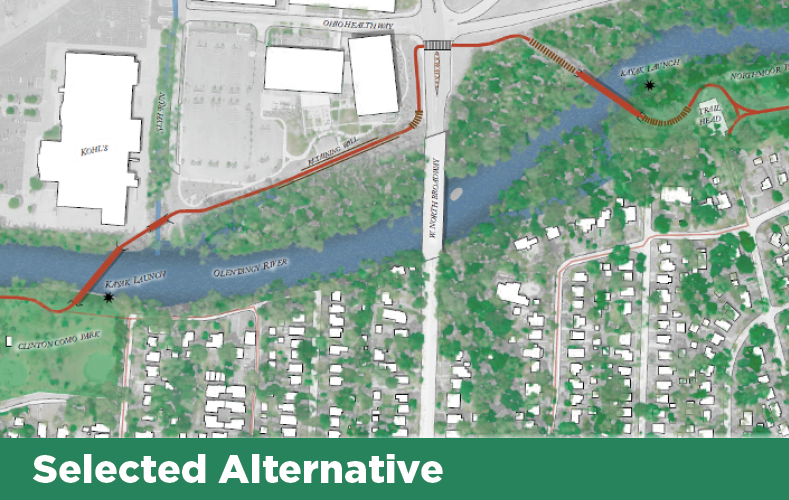
Olentangy Trail Update about Northmoor Park to Clinton-Como Park
Olentangy Trail Completion Update — Crossing Safety
Enhancements Unveiled
In response to feedback from the
public and the anticipated high volume of pedestrians and cyclists crossing
North Broadway, multiple safety enhancements will be implemented at this
location, including:
- High
visibility crosswalks.
- High visibility, oversized “No Turn On Red” LED signs that are
activated when trail users press the pedestrian crossing button.
- A Leading Pedestrian Interval (LPI) was added to the signal
timing, which gives trail users a three to seven second head start when
entering the crosswalk, occurring before the corresponding green light signal
activates for motorists.
- Designated
waiting areas on both sides of the street for pedestrians and bicyclists to
wait for the signal to change.
- Center
concrete median with reboundable plastic pylons to slow traffic and identify
the crossing as a high pedestrian area.
- Enhanced
signage, including “Trail Crossing” signs.
Get details and download the complete North Broadway
Crossing Safety Enhancement Summary.
Environmental studies and engineering design for the completion of the Olentangy Trail between Clinton-Como Park and Northmoor Park are nearly finished.
Summaries of public comments and responses on floodplain and construction impacts are now available.
Floodplain impacts comments and responses summary
Construction impacts (Section 4f) comments and responses summary
In addition, the Ohio Department of Transportation (ODOT) has approved the project’s Categorical Exclusion document.
Timeline
At this time, the project is on schedule for construction to begin in 2024.

When complete, this project will close the final gap of the Olentangy Trail and enhance connectivity for thousands of walkers, cyclists and runners.
Olentangy Trail Completion Online Public Meeting - Jan. 21, 2021
The City of Columbus and its partners are evaluating options to complete the Olentangy Trail by connecting Clinton-Como and Northmoor Parks with a dedicated, 0.6 mile shared use path.
The Olentangy Trail offers a seamless route from Worthington to downtown Columbus. This trail winds through several neighborhoods along the Olentangy River, with trailheads at several major city parks, including Antrim Park and Whetstone Park. The path also travels through the heart of the Ohio State University campus.